Arnaville
Durée visite : 20 min
Moyen : pédestre


Une présence néolithique de 5000 ans avant notre ère est attestée. Arnaville dépendait en partie de la Lorraine et en partie de la Terre de Gorze, donc du roi de France. Il ne fut incorporé entièrement au duché de Lorraine qu’entre 1718 et 1766. A cette date, il passe à la France. Cette commune fut un village-frontière avec l’Allemagne entre 1871 et 1918. Le traité de Francfort en 1871 place la frontière franco-allemande entre Arnaville et Novéant au nord. Non défendu, le village est occupé dès le premier jour du conflit de 1914-1918. Arnaville fut le théâtre de dramatiques combats au cours de la bataille de Metz en septembre 1944. Ils opposaient la Ve division de la IIIe armée américaine à la 462e Infanterie-Division allemande. Celle-ci était appuyée par des panzers des 3e, 15e et 17e SS-Panzergrenadier-Division. Alors que la tête de pont de Dornot est évacuée le 10 septembre 1944, la IIIe armée américaine reprend pied sur la rive ouest de la Moselle dans le secteur d’Arnaville. Pour la première fois en Europe, l’armée américaine utilise des écrans de fumigènes dans une opération offensive. L’opération menée par le 84e Chimical Engineer Compagnie est un succès. Le 12 septembre, la contre attaque allemande est prévisible. Différentes unités sont engagées aux côtés du bataillon Vogt de la 462eInfanterie-Division pour contenir la tête de pont d’Arnaville. L’artillerie de campagne allemande, soutenue par les batteries des forts Driant (Kronprinz) et Verdun (Haeseler), pilonne les troupes américaines. De son côté, l’artillerie américaine répond par un tir de barrage soutenu, tirant plus de 5700 salves sur ce secteur. L’aviation américaine appuie ses troupes au sol. Elle détruit, par un coup au but, une batterie du fort Sommy, dans le Groupe fortifié Verdun, et des batteries lourdes situées près de Mardigny. Les régiments de PanzerGrenadier et le bataillon Vogt supportent de lourdes pertes. Plus de dix Panzers et plusieurs half-tracks allemands furent détruits ce 12 septembre 1944.
A Neolithic presence of 5000 years before our era is attested. Arnaville depended partly on Lorraine and partly on the Terre de Gorze, therefore on the King of France. It was not fully incorporated into the Duchy of Lorraine between 1718 and 1766. On this date, it moved to France. This town was a border village with Germany between 1871 and 1918. The Treaty of Frankfurt in 1871 places the Franco-German border between Arnaville and Novéant to the north. Undefended, the village was occupied from the first day of the 1914-1918 conflict. Arnaville was the scene of dramatic fights during the Battle of Metz in September 1944. They opposed the Fifth Division of the Third American Army to the 462nd German Infantry-Division. This was supported by panzers from the 3rd, 15th and 17th SS-Panzergrenadier-Division. While the Dornot bridgehead was evacuated on September 10, 1944, the American Third Army regained a foothold on the west bank of the Moselle in the Arnaville sector. For the first time in Europe, the US military is using smoke screens in an offensive operation. The 84th Chemical Engineer Company’s operation is a success. On September 12, the German counterattack is foreseeable. Different units are engaged alongside the Vogt battalion of the 462nd Infantry-Division to contain the Arnaville beachhead. The German field artillery, supported by the batteries of forts Driant (Kronprinz) and Verdun (Haeseler), pounded the American troops. For its part, the US artillery responded with sustained barrage, firing more than 5,700 rounds in the area. The US air force is supporting its troops on the ground. It destroys, by a blow to the goal, a battery of Fort Sommy, in the fortified Verdun Group, and heavy batteries located near Mardigny. The PanzerGrenadier regiments and the Vogt battalion suffered heavy losses. More than ten Panzers and several German half-tracks were destroyed on September 12, 1944.
Eine neolithische Präsenz von 5000 Jahren vor unserer Zeit ist belegt. Arnaville war teilweise von Lothringen und teilweise von den Terre de Gorze abhängig, daher vom König von Frankreich. Es wurde erst zwischen 1718 und 1766 vollständig in das Herzogtum Lothringen eingegliedert. An diesem Tag zog es nach Frankreich. Diese Stadt war zwischen 1871 und 1918 ein Grenzdorf zu Deutschland. Mit dem Frankfurter Vertrag von 1871 liegt die deutsch-französische Grenze zwischen Arnaville und Novéant im Norden. Unverteidigt war das Dorf vom ersten Tag des Konflikts zwischen 1914 und 1918 besetzt. Arnaville war Schauplatz dramatischer Kämpfe während der Schlacht von Metz im September 1944. Sie stellten die fünfte Division der dritten amerikanischen Armee der 462. deutschen Infanteriedivision entgegen. Dies wurde von Panzern der 3., 15. und 17. SS-Panzergrenadier-Division unterstützt. Während der Dornot-Brückenkopf am 10. September 1944 evakuiert wurde, konnte die amerikanische Dritte Armee am Westufer der Mosel im Sektor Arnaville wieder Fuß fassen. Zum ersten Mal in Europa setzt das US-Militär in einer Offensivoperation Rauchgitter ein. Der Betrieb der 84. Chemical Engineer Company ist ein Erfolg. Am 12. September ist der deutsche Gegenangriff absehbar. Neben dem Vogt-Bataillon der 462. Infanteriedivision werden verschiedene Einheiten eingesetzt, um den Brückenkopf von Arnaville aufzunehmen. Die deutsche Feldartillerie, unterstützt von den Batterien der Forts Driant (Kronprinz) und Verdun (Haeseler), schlug die amerikanischen Truppen. Die US-Artillerie reagierte ihrerseits mit anhaltendem Sperrfeuer und feuerte mehr als 5.700 Patronen in der Region ab. Die US-Luftwaffe unterstützt ihre Truppen vor Ort. Es zerstört durch einen Schlag gegen das Tor eine Batterie von Fort Sommy in der befestigten Verdun-Gruppe und schwere Batterien in der Nähe von Mardigny. Die PanzerGrenadier-Regimenter und das Vogt-Bataillon erlitten schwere Verluste. Mehr als zehn Panzer und mehrere deutsche Halbschienen wurden am 12. September 1944 zerstört.

D’or à la bande de gueules chargée de trois alérions d’argent accompagnée en chef d’un Saint Gorgon d’azur et en pointe d’une crosse et d’une épée mises en pal de même.
Arnaville était divisée en trois seigneuries. Le ban Saint Pierre appartenait au duc de Lorraine (Les armes de Lorraine simple constituant le champ de l’écu). Le ban Saint Gorgon appartenait à l’abbé de Gorze (Le Saint Gorgon en chef). Le ban Saint Vanne appartenait à l’évêque de Verdun (La crosse et l’épée en pointe). Ce blason est utilisé par la commune depuis 1979.
Of gold with a bend Gules charged with three alerions Argent accompanied in chief by a Saint Gorgon Azure and in base of a butt and a sword set in pale in the same way.
Arnaville was divided into three seigneuries. The ban Saint Pierre belonged to the Duke of Lorraine (The arms of Lorraine simple constituting the field of the shield). The ban Saint Gorgon belonged to the abbot of Gorze (The Saint Gorgon in chief). The ban Saint Vanne belonged to the bishop of Verdun (Butt and sword point)
). This coat of arms has been used by the municipality since 1979.
Von Gold mit einer Biegung Gules, die mit drei Alerionen Silber aufgeladen ist, begleitet von einem Saint Gorgon aus Azurblau und in der Spitze eines Hinterns und eines Schwertes, die auf die gleiche Weise blass gesetzt sind.
Arnaville wurde in drei Seigneuries unterteilt. Das Verbot Saint Pierre gehörte dem Herzog von Lothringen. Das Verbot des Heiligen Gorgon gehörte dem Abt von Gorze (dem Obersten Gorgon). Das Verbot der Heiligen Vanne gehörte dem Bischof von Verdun (
Hintern und Schwertspitze ). Dieses Wappen wird seit 1979 von der Gemeinde verwendet.

Les habitants d’Arnaville s’appellent les Arnavillois et les Arnavilloises.
The inhabitants of Arnaville are called Arnavillois and Arnavilloises.
Die Einwohner von Arnaville heißen Arnavillois und Arnavilloises.
Les points de visites
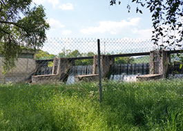
Le Rupt de Mad coule dans les deux départements de Meuse et Meurthe-et-Moselle. C’est un affluent gauche de la Moselle, par conséquent un sous-affluent du Rhin. Né dans les Côtes de Meuse, au nord de Commercy, sur la commune de Geville, à 285 m d’altitude, il prend une direction Nord-Est pour traverser le département de Meurthe-et-Moselle. Il rejoint la Moselle à Arnaville, à 174 m d’altitude. Avec 54,6 km de longueur, le Rupt de Mad s’écoule successivement sur trois types de formations : les argiles de la Woëvre, les calcaires du Bajocien et les argiles du Toarcien avant de confluer avec la Moselle. Son principal affluent est la Madine, émissaire du lac de Madine, dont elle reçoit les eaux en rive gauche. En amont de la commune d’Arnaville, une retenue d’eau d’une capacité maximale de 330 000 m3 a été aménagée. Elle sert de réservoir intermédiaire pour l’alimentation en eau de l’agglomération messine, via la station de traitement de Moulins-lès-Metz.
The Rupt de Mad flows in the two departments of Meuse and Meurthe-et-Moselle. It is a left tributary of the Moselle, therefore a sub-tributary of the Rhine. Born in the Côtes de Meuse, north of Commercy, in the town of Geville, at an altitude of 285 m, he heads north-east to cross the department of Meurthe-et-Moselle. It joins the Moselle at Arnaville, at an altitude of 174 m. With a length of 54.6 km, the Rupt de Mad flows successively over three types of formations: the clays of the Woëvre, the limestones of the Bajocian and the clays of the Toarcien before merging with the Moselle. Its main tributary is the Madine, emissary of Lake Madine, from which it receives water on the left bank. Upstream from the town of Arnaville, a water reservoir with a maximum capacity of 330,000 m3 has been built. It serves as an intermediate reservoir for the water supply to the Metz agglomeration, via the Moulins-lès-Metz treatment station.
Der Rupt de Mad fließt in die beiden Departements Maas und Meurthe-et-Moselle. Es ist ein linker Nebenfluss der Mosel, daher ein Nebenfluss des Rheins. Er wurde in den Côtes de Meuse nördlich von Commercy in der Stadt Geville auf 285 m Höhe geboren und fährt nach Nordosten, um das Departement Meurthe-et-Moselle zu überqueren. Es mündet in Arnaville auf 174 m Höhe in die Mosel. Mit einer Länge von 54,6 km fließt der Rupt de Mad nacheinander über drei Arten von Formationen: die Tone des Woëvre, die Kalksteine des Bajocian und die Tone der Toarcien, bevor er mit der Mosel verschmilzt. Sein Hauptzufluss ist die Madine, Abgesandte des Madine-Sees, von der sie am linken Ufer Wasser erhält. Vor der Stadt Arnaville wurde ein Wasserreservoir mit einer maximalen Kapazität von 330.000 m3 gebaut. Es dient als Zwischenreservoir für die Wasserversorgung der Metz-Agglomeration über die Kläranlage Moulins-lès-Metz.
.
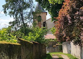
A la fin du Xème siècle, Saint-Etienne n’est encore qu’une chapelle située en plein milieu d’une vigne, à ce moment encore propriété de l’abbaye de Gorze. L’arrivée des premiers ducs de Lorraine, avoués à l’abbaye de Saint-Pierre-aux-Nonnains, freina l’élan gorzien en aval du Rupt de Mad, bien que les alentours du petit sanctuaire fussent progressivement aménagés. Avant le Xème siècle, des serfs, des convers et quelques clercs furent installés dans ce qui devint l’aître fortifié après l’An Mil. Dans les siècles suivants, trois autres abbayes acquirent de nouveaux biens à Arnaville : Saint-Pierre-aux-Nonnains, Saint-Vanne de Verdun et Sainte-Marie-aux-Bois, création ducale proche de Prény. L’arrivée de leurs personnels a créé la spécificité d’Arnaville. La façade de la tour-clocher fortifiée était alors encore dissimulée derrière l’aile gauche du fer à cheval. En 1749, l’aître comportait encore ses deux ailes. Celle de droite était très large et finissait à son extrémité par se confondre avec le village. Sur les plans de 1821, l’aile droite a totalement disparu. De forme carrée, la tour romane atteint 7 mètres d’épaisseur de mur. L’entrée, aujourd’hui au rez-de-chaussée, se faisait autrefois plus haut, comme pour un donjon. Dans le secteur correspondant à ce que fut l’aile droite de l’aître, on ne trouve aujourd’hui plus rien. L’aile gauche a conservé son cachet médiéval. Face à l’entrée de l’église, se dressent deux maisons médiévales.
At the end of the 10th century, Saint-Etienne was still only a chapel located in the middle of a vineyard, at this time still owned by the Abbey of Gorze. The arrival of the first Dukes of Lorraine, confessed to the abbey of Saint-Pierre-aux-Nonnains, slowed down the Gorzian momentum downstream from the Rupt de Mad, although the surroundings of the small sanctuary were gradually developed. Before the 10th century, serfs, lay brothers and some clerics were installed in what became the fortified aist after the year 1000. In the following centuries, three other abbeys acquired new goods in Arnaville: Saint-Pierre-aux-Nonnains, Saint-Vanne de Verdun and Sainte-Marie-aux-Bois, ducal creation near Prény. The arrival of their staff has created the specificity of Arnaville. The facade of the fortified bell tower was then still hidden behind the left wing of the horseshoe. In 1749, the aster still had its two wings. The one on the right was very wide and ended up blending into the village at its end. On the plans of 1821, the right wing has completely disappeared. Square in shape, the Romanesque tower has a wall thickness of 7 meters. The entrance, today on the ground floor, was once higher, as for a dungeon. In the sector corresponding to what was the right wing of the aître, nothing can be found today. The left wing has retained its medieval cachet. Opposite the entrance to the church, stand two medieval houses.
Ende des 10. Jahrhunderts war Saint-Etienne nur noch eine Kapelle inmitten eines Weinbergs, zu dieser Zeit noch im Besitz der Abtei von Gorze. Die Ankunft der ersten Herzöge Lothringens, die der Abtei Saint-Pierre-aux-Nonnains gestanden hatten, verlangsamte den gorzianischen Schwung stromabwärts des Rupt de Mad, obwohl sich die Umgebung des kleinen Heiligtums allmählich entwickelte. Vor dem 10. Jahrhundert wurden Leibeigene, Laienbrüder und einige Geistliche in dem nach dem Jahr 1000 befestigten Aist eingesetzt. In den folgenden Jahrhunderten erwarben drei weitere Abteien in Arnaville neue Güter: Saint-Pierre-aux-Nonnains, Saint-Vanne de Verdun und Sainte-Marie-aux-Bois, herzogliche Schöpfung in der Nähe von Prény. Die Ankunft ihrer Mitarbeiter hat die Besonderheit von Arnaville geschaffen. Die Fassade des befestigten Glockenturms war damals noch hinter dem linken Flügel des Hufeisens verborgen. 1749 hatte die Aster noch zwei Flügel. Der rechts war sehr breit und mischte sich am Ende in das Dorf ein. Nach den Plänen von 1821 ist der rechte Flügel vollständig verschwunden. Der romanische Turm hat eine quadratische Form und eine Wandstärke von 7 Metern. Der Eingang, heute im Erdgeschoss, war einst höher als bei einem Verlies. In dem Sektor, der dem rechten Flügel des Aître entsprach, ist heute nichts mehr zu finden. Der linke Flügel hat sein mittelalterliches Gütesiegel beibehalten. Gegenüber dem Eingang zur Kirche stehen zwei mittelalterliche Häuser.
.