Belval
Durée visite : 20 minutes
Moyen : Pédestre


Le village faisait partie de la principauté de Salm, rattachée à la France en 1793. Il se situe au pied du col du Hantz, tout près de l’Alsace. Entre 1870 et 1918, il était un poste-frontière, l’Allemagne ayant annexé l’Alsace. Comme tous les villages de la région, ses habitants étaient pour la plupart des agriculteurs, en 2014, un seul d’entre eux est encore éleveur. Ils ont vécu l’essor des textiles après la guerre de 1870 avec l’implantation d’usines. La très grande majorité des terres cultivées et des pâturages ont été remplacés par des plantations à vocation forestière. On trouve alors l’épicéa et le sapin, occasionnant une descente de la forêt dans la vallée. Une riche famille d’industriels, les Nansé, y bâtit un château au début du XXe siècle, dit château de Belval, alors qu’en réalité il se situe sur la commune voisine du Saulcy. La guerre 1914-1918 eut des conséquences très dures pour la population, car le village se situait juste à l’arrière de la ligne de front, côté allemand. Il subsiste un cimetière dit des Roumains qui a été retrouvé après la grande tempête de 1999. La Seconde Guerre mondiale apporta aussi son lot de désolations. En 1944, après un parachutage d’armes plus ou moins réussi, la Gestapo arrêta des dizaines de personnes accusées de résistance dans les villages des alentours, pour être réunies à Belval puis emmenées dans les camps. Beaucoup n’en revinrent pas.
The village was part of the principality of Salm, attached to France in 1793. It is located at the foot of the Hantz, near Alsace. Between 1870 and 1918, it was a border post, Germany having annexed Alsace. Like all villages in the region, its inhabitants were mostly farmers, in 2014, only one of them is still a farmer. They experienced the rise of textiles after the war of 1870 with the establishment of factories. The vast majority of cultivated land and pastures have been replaced by forest plantations. Then we find the spruce and fir, causing a descent of the forest in the valley. A rich family of industrialists, the Nansé, built a castle at the beginning of the 20th century, called Belval Castle, when in fact it is located on the neighboring town of Saulcy. The 1914-1918 war had very harsh consequences for the population, as the village was just behind the front line on the German side. There remains a Romanesque cemetery that was found after the great storm of 1999. The Second World War also brought desolations. In 1944, after a parachute of more or less successful arms, the Gestapo arrested dozens of people accused of resistance in the surrounding villages, to be reunited in Belval then taken to the camps. Many did not come back.
Das Dorf war Teil des Fürstentums Salm, das 1793 mit Frankreich verbunden war. Es liegt am Fuße des Hantz, in der Nähe des Elsass. Zwischen 1870 und 1918 war es ein Grenzposten. Deutschland hat das Elsass annektiert. Wie alle Dörfer der Region waren die Einwohner überwiegend Landwirte, 2014 ist nur noch einer der Landwirte. Sie erlebten den Aufstieg von Textilien nach dem Krieg von 1870 mit der Gründung von Fabriken. Die überwiegende Mehrheit der Anbauflächen und Weiden wurde durch Waldplantagen ersetzt. Dann finden wir die Fichte und die Tanne, wodurch der Wald im Tal absteigt. Die reiche Industriellenfamilie Nansé errichtete zu Beginn des 20. Jahrhunderts ein Schloss, das Belval Castle, obwohl es in der Nachbarstadt Saulcy liegt. Der Krieg von 1914 bis 1918 hatte sehr harte Folgen für die Bevölkerung, da sich das Dorf auf deutscher Seite unmittelbar hinter der Frontlinie befand. Es gibt einen romanischen Friedhof, der nach dem großen Sturm von 1999 gefunden wurde. Der Zweite Weltkrieg brachte auch Verwüstungen mit sich. Nach einem Fallschirm mit mehr oder weniger erfolgreichen Waffen verhaftete die Gestapo 1944 Dutzende von Menschen, die in den umliegenden Dörfern des Widerstands angeklagt wurden. Sie wurden in Belval wiedervereinigt und in die Lager gebracht. Viele kamen nicht zurück.
Les points de visites
.
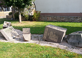
En 1985 un camion-citerne a provoqué d’importants désastres dans le village. Le feu a détruit quelques maisons et le monument aux morts s’est écroulé pendant l’accident. Il datait de 1927. Un nouveau monument a été érigé derrière les restes du premier, laissé en l’état. Il est consacré aux victimes de la commune des deux guerres mondiales. Le soldat Camille Boissenin est mort de maladie le 12 novembre 1918, à Salonique en Grèce. Cet artilleur appartenait à l’armée d’Orient. Bertrand Tavernier l’a évoquée dans Capitaine Conan. En 39-45, des habitants sont morts en déportation. Cette stèle est ornée d’une croix de Lorraine et d’une croix de guerre. Sur une plaque située au pied de la stèle, on peut lire : Ici a été déposée de la terre de Dachau. 22-11-1945.
In 1985 a tanker truck caused major disasters in the village. The fire destroyed some houses and the war memorial collapsed during the accident. It dated from 1927. A new monument was erected behind the remains of the first, left in the state. It is dedicated to the victims of the commune of the two world wars. Private Camille Boissenin died of illness on November 12, 1918, in Salonika, Greece. This gunner belonged to the army of the East. Bertrand Tavernier mentioned it in Captain Conan. In 39-45, people died in deportation. This stele is decorated with a cross of Lorraine and a cross of war. On a plaque at the foot of the stela, it says: Here was deposited from the land of Dachau. 22-11-1945.
1985 verursachte ein Tanklastwagen große Katastrophen im Dorf. Das Feuer zerstörte einige Häuser und das Kriegerdenkmal brach während des Unfalls zusammen. Es stammt aus dem Jahr 1927. Hinter den Überresten des ersten im Staat verbliebenen Denkmals wurde ein neues Denkmal errichtet. Es ist den Opfern der Kommune der beiden Weltkriege gewidmet. Die private Camille Boissenin starb am 12. November 1918 in Thessaloniki (Griechenland) an Krankheit. Dieser Schütze gehörte der Armee des Ostens. Bertrand Tavernier erwähnte es in Captain Conan. In den Jahren 39-45 starben Menschen durch Deportation. Diese Stele ist mit einem Lothringerkreuz und einem Kreuz des Krieges verziert. Auf einer Gedenktafel am Fuße der Stele heißt es: Hier wurde aus dem Land Dachau deponiert. 22-11-1945.
.
.
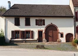
C’est un bel exemple de ferme répandu dans cette région des Vosges. A droite, on distingue la petite porte de l’étable. A côté, la porte charretière ouvre sur la grange. Là était entreposé le foin, la paille, les récoltes et le matériel. A gauche se trouve le logis. Le grenier a été aménagé en habitation. Le toit longtemps en chaume a été remplacé au XVIIIe siècle par la tuile mécanique. C’était une mesure anti-incendie. Notez la sculpture au-dessus du linteau. On peut déchiffrer la date possible de la construction. Des initiales peuvent indiquer le nom des habitants de l’époque.
This is a beautiful example of a farm spread in this region of the Vosges. On the right, there is the small door of the barn. At the side, the carriage door opens on the barn. There was stored hay, straw, crops and equipment. On the left is the house. The attic has been converted into a dwelling. The long thatched roof was replaced in the 18th century by the mechanical tile. It was an anti-fire measure. Note the sculpture above the lintel. We can decipher the possible date of construction. Initials may indicate the names of the inhabitants of the time.
Dies ist ein schönes Beispiel für eine Farm, die in dieser Region der Vogesen verbreitet ist. Rechts ist die kleine Scheunentür. An der Seite öffnet sich die Wagentür im Stall. Es wurde Heu, Stroh, Getreide und Ausrüstung gelagert. Auf der linken Seite ist das Haus. Der Dachboden wurde in eine Wohnung umgewandelt. Das lange Reetdach wurde im 18. Jahrhundert durch mechanische Ziegel ersetzt. Es war eine Anti-Feuer-Maßnahme. Beachten Sie die Skulptur über dem Sturz. Wir können das mögliche Konstruktionsdatum entschlüsseln. Initialen können die Namen der Bewohner der Zeit angeben.